


Horseback Riding Trails
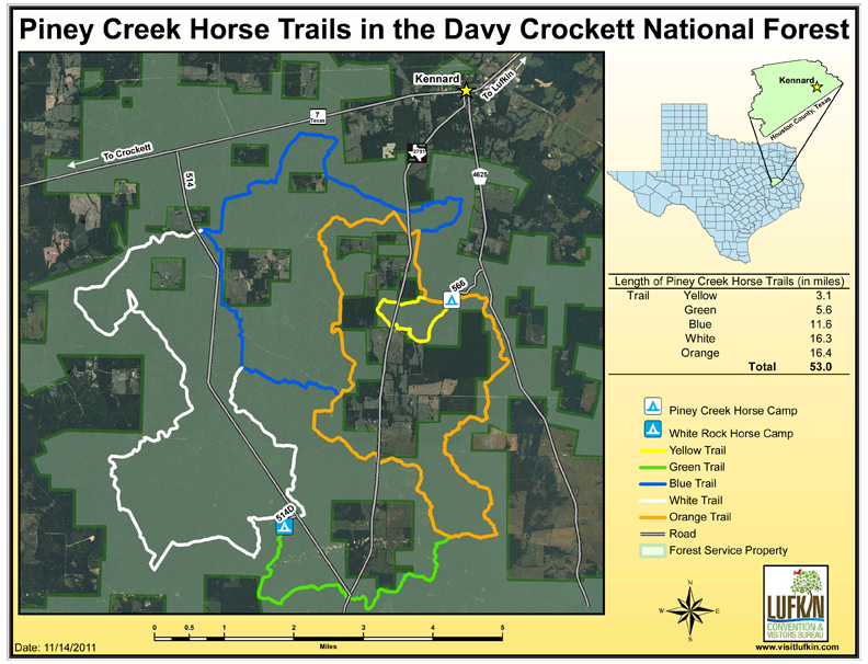
The Piney Creek Horse Trails are located in the Davy Crockett National Forest and meander for approximately 53 miles through varying plant communities, changing topography and different forest management techniques. A trail of this length will provide riders with great opportunities to view numerous wildlife and bird species, as well as spend quality time with family and friends. There are two camping areas along this trail that will allow riders to make this a multi-day activity. It is advised that riders visit the National Forests and Grasslands in Texas website at www.fs.usda.gov/texas before accessing this trail in order to obtain any pertinent information about the appropriate terms and conditions of the trail. View a map of the Piney Creek Horse Trails.
Piney Creek Horse Camp Trailhead: From Lufkin, follow State Hwy 103 west for 12 miles until it merges into State Hwy 7. Continue west for 13 miles to Kennard. Turn left on CR 4625. Go 2.5 miles until you see Piney Creek Horse Camp sign. Turn right and travel 1 mile. (N 31° 19’ 3” W 95° 11’ 10”)
White Rock Horse Camp Trailhead: From Lufkin, follow State Hwy 103 west for 12 miles until it merges into State Hwy 7. Continue west for approximately 19 miles, turn south on Forest Service Rd 514 and travel 10 miles to the White Rock Horse Camp on Forest Service Rd 514-D. Turn right. (N 31° 16’ 5” W 95° 13’ 36”)
Ebenezer Horse Trails
Advanced/Horseback Riding/1.13 miles within park; branches into Angelina National Forest for 20+ miles
From Lufkin, take US Hwy 69 south approximately 18 miles. Take Texas 63 east 18 miles and turn left onto Hwy 255. Travel 3.2 miles and turn left
on CR 335B. (N 31° 04’ 10” W 94° 07’ 31”)